Great Western Loop: Day 40-43: Chama to Pagosa Springs
- JustagermanHiker

- 13. Mai 2021
- 5 Min. Lesezeit
Day 40: A whole new world (17.5miles)
The last two days in Chama with Golden had been amazing. It was a great distraction from the race and I really enjoyed talking about US/German politics and several other topics with him.
Day 40 started with a nice breakfast burrito at Fina's Diner. Golden had agreed to take me and two other hikers, Hummingbird and Sky, to the trailhead at Cumbress Pass.
No one really knew what to expect, except for snow. It seems like we're the spearhead of this hiking season. There's no information on hikers that are currently ahead of us.
The trail distance between Chama and Pagosa Springs is only 78miles. A distance that I could usually cover in 2 days, but given all the uncertainty in regards to the snow and trail conditions I brought food for 3.5 days.

Hummingbird, Sky and I started at Cumbress Pass at about 8am and stayed together for the majority of the day. We hit snow right at the trailhead, but found some sections that were at least hikeable. In the early afternoon these dry patches started to disappear and my snowshoes became invaluable.

With more snow on the trail Hummingbird and Sky started falling behind, as I was the only one with snowshoes.

I waited several times for them to catch up, but when they didn't show and I started to get cold, I decided to move on.

As I made it to the top of a mountain range, I saw them in the far distance. I waited again, but than assumed they set up camp at one of the lakes.
I moved on for another hour and found a tiny spot that was not covered by snow and pitched my tent.
With only 17.5 miles, my mileage had dropped by 50%. The weight of the newly added snowshoes, ice-axe, crampons, gaiters and sunglasses definitely had an impact on my performance, but snow and the high altitude and the additional need to constantly navigate and check my GPS-location, slowed me down even further.
Day 41: Whiteouts (22.5miles)
The night had been extremely windy, but my tent did a great job and kept me safe and warm.

Most streams are covered under several inches of snow and lakes are frozen, so the easiest option to get water, was melting it. This usually takes quite some time, especially when you have no water to start with. If you're not patient, you end up burning the snow, which creates an awful taste. So heating up water, and than adding snow, is what usually works best.

The weather on day 41 was rough.
We already had to endure some extreme winds the day before, but this day it got even worse. Especially at elevations of 12,000ft or more, the wind just pushed me around.

The weather continously worsened. In the afternoon it started to snow and the wind got even more intense.

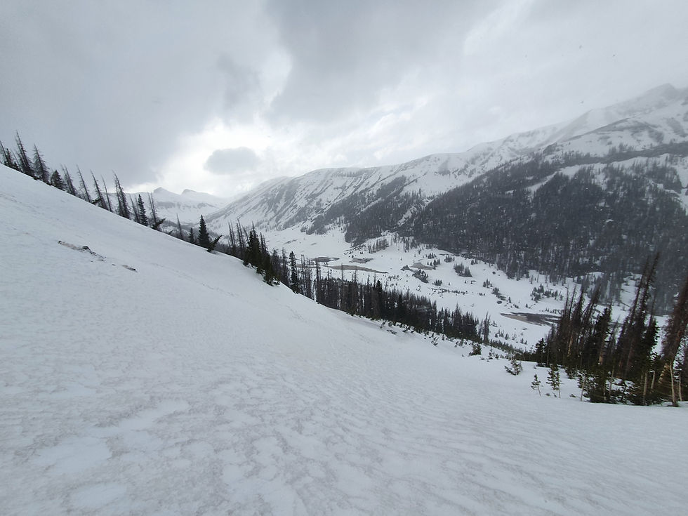
(The trail went into the valley on the left side of this picture and than climbed back up, and followed the ridge just above the treeline that you can see on the far end of the valley. It than crossed a mountain pass on the right side of the picture (background))
While trying to find the trail and hiking on a steep mountain slope, I experienced whiteout conditions. The wind got so intense that I was afraid of being blown off the mountain. In addition to that the visibility dropped to just a mere 10yards. It was all white. I couldn't see anymore where I was going, nor how steep the next part was. So I decided to just ram my ice-axe into the snow and lay down as low as possible. A few minutes later, the situation improved and I made it to the next mountain pass safely.

At 6pm I was hoping for an easier hiking experience, as the trail would drop significantly. Unfortunately I found myself, yet again on a pretty steep mountain slope, with terrible snow conditions.

-
Instead of following an invisible trail along a sketchy slope, I decided to drop down into the valley and started looking for a sheltered and snow-free tent site.
Day 42: Snowfall (19.5miles)
In my mind I had played with the idea of making it to Wolf Creek Pass and Highway 160 (Road into Pagosa Springs) on day 42. 27.5 miles seemed very far, but not totally unrealistic until I woke up...

3-5 inches of snow had fallen over night and created an even more beautiful and stunning environment.

-

With clear skies, I was looking forward to a beautiful day. I immediately put my snowshoes on and started a slow, but steady 1700ft climb.
The views were amazing. Just snow, my footprints and impressive mountains all around me.

-
After making it to the tip of the first climb, the "trail" stayed on 12,000ft and offered the most amazing snow hiking experience I've ever had.

-

At 9am I got to the first tricky section. The trail ahead looked to steep to go down. I tried climbing up the ridge, but faced a cliff. I than returned trying to find a place on the western side of that ridge, but that also ended in a steep drop off.
For some 25minutes I hiked up and down that ridge, looking for a safe way down into a small canyon. I finally decided to pull my ice-axe out, climb down as far as I could and than swith into a controlled glissade.

(doesn't look that steep from below...but you get an idea where I glissaded)
In the end, it wasn't as bad as I had expected and the fresh snow helped me to slow down and control my glissade.

For the rest of the day I crossed endless snowfields and beautiful ridges.
Knowing that Sky and Hummingbird would most likely follow my footprints, my biggest concern was finding a place to poop, without them following me. I ended up laying footprints with my snowshoes and than taking them off, before walking another 10yards to a nearby tree.

At the end of the day I was still some 10miles from Wolf Creek Pass and the trail started to get really bad. Now, at an elevation of some 11,000ft. the trail was only partly covered in snow. I oftentimes had to switch between snowshoes and hiking shoes. The trail became an obstacle course with some extremely steep sections. I got more and more worried and pulled out my ice-axe once again. As I got more exhausted and my footing more insecure, it happened. I slipped and started sliding down the mountain.
Luckily my reaction was quick and precise. I hammered my ice-axe into the snow, raised my legs and put all my weight on top of the ice-axe until I came to a hold.
After catching my breath and looking into the valley below my feet, I started climbing up to recover a trekking pole that I had lost during the slide. I had slid down for maybe 10-15yards.
Without the ice-axe I would have survived the fall, but also would have ended up some 30-40yards below in the valley, maybe with a minor injury.

(this is not where I slipped, just a random picture).
After this incident and an incredibly rough time with postholing, climbing over blowdowns and route finding, I called it the day, melted some snow and went to bed. 8 miles from Wolf Creek Pass.
Day 43: Pagosa Springs (8miles)
After a frustrating and slow going end of day 42, I wanted to get out of the forest as soon as possible. The night's freezing temperatures made the snow rock-solid again and made it much easier to move on. Nevertheless, it still remained slow going and difficult, because of all the blowdowns. After just 2miles I saw the Alberta Park Reservoir to the north, just 0.3miles from my position. Looking at the map, I realised it was connected to a Forest Service Road, which again was connected to highway 160. So I cut some 5 trail miles and went cross-country to the reservoir and the highway.

After some 30minutes on the highway, I got a hitch to Pagosa Springs, a beautiful town with some nice Hot Springs, 25miles from the trail.


Kommentare