Great Western Loop: Day 9-17 (Pine to Superior)
- JustagermanHiker

- 25. März 2020
- 9 Min. Lesezeit
Day 9: Pine to Payson (12m)
I left Pine in the late afternoon and due to my commitment of pursuing a "continuous footprint" I started hiking along the highway towards Payson. A quick stop at the Early Bird Cafe for a Denver Omelett and some coffee helped to get going. The hike along the highway really sucked and the monotonous ground and hiking style soon started to cause some pain in my feet.

In addition to that I was hiking in the only dry socks I had left, and these were my wool-sleeping socks which already had quite some holes. Close to the halfway point a car stopped and offered me a ride, which I thankfully declined. At about 2pm I arrived in Payson and started resupplying for the next section to Roosevelt Lake and Superior. I also tried to replace some gear, as my backpack really starts to fall apart. My front mesh-pocket is torn and beyond repairing (already done that twice with tenacious tape and floss), one of the clips to close the pack is also gone and a cut goes along the upper right side of the pack, so that rain can easily get inside. Unfortunately Payson didn't have a proper Outdoor store and so the only items I could replace were some socks. Besides my sleeping socks, I also had to replace a pair of Darn Toughs, which I lost due to the broken mesh pocket. The rest of the day I spent with updating myself on the current covid-19 situation and on planning my way back to the Arizona Trail. I eventually decided to hike 12miles to the Mineral Springs Trailhead and than climb 2,000ft on the North Peak Trail which would reconnect some 5miles later with the AZT.

Day 10: Payson to 370.9 (23.3m)
My alarm went off at 6:30am and I quickly packed my belongings und headed to the next Cafe for breakfast. I enjoyed eavesdropping on the locals talking about Trump and started hiking towards the AZT at 7:30am. It was a nice and beautiful day, but I somehow didn't feel like hiking. My thoughts were on the current covid-19 situation and how it might affect my hike. The route I had chosen lead through Paysons School District and a Golf course, before following a dirt road for 5miles to the trailhead.

From there it was a rather steep climb on an overgrown trail back to the AZT. I didn't have any problems following the trail, except for the last 300ft. It was frustrating, I knew where I had to go and that the junction was right ahead, but I couldn't see the trail and the bush was so thick and thorny that I had to go back and forth several times until I finally made it back to the AZT.

-
Those 300ft. cost almost half an hour and got me even more frustrated. After that initial 2,000ft. ascent I climbed another 1,000ft. to rocky ridge, where I found an empty tent. (Guess the hiker summited North Peak mountain at that time). Just minutes later I met the first 3 nobo hikers in days and ended up taking to them about the conditions ahead of them.

-

-

I decided to only hike another few miles to Chilson Camp, an established campsite, and pitched there at 6pm. Quite early for me, but after a quite restless night in Payson, I just felt like going to bed early.

-
Day 11: 370.9 to 400.9 (30m)
Day 11 also started quite slow. I had planned for a rather long day, but met quite a few thru- and day hikers along the way. I probably spent 1.5 hours just talking to different groups of people and lost quite some precious time here. My goal was to get to the Highway 31miles from my starting point, which looked easy enough on the elevation profile as it was mainly downhill. In fact, the trail wasn't as fast as I expected, as I had to hike through several washes and over quite some rocky terrain.

-

It wasn't a very spectacular trail and due to all the time lost talking, it already got dark before I got to the highway. Some 2miles before the highway I had to get my headlamp out and managed to find a nice campsite just a mile from my initial goal. This was good enough, as I wasn't keen on sleeping right next to the highway.
Day 12: 400.9 to 431.6 (30.7m)
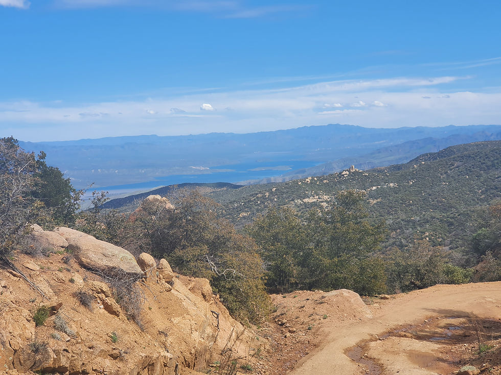
With a total ascent of 5800ft (1750m), I prepared to yet another tough day. I quickly filled one of my water bladders at the local cache (river water was quite disgusting at times, due to the heavy flooding) and started a gentle climb towards the ridge above Lake Roosevelt.

The initial climb wasn't as bad as expected and the trail continued on a dirt road after some 1,800ft (500m) over 10miles. The road allowed good progress, I just had to make sure not to be overrun by the many ATV's (All terrain vehicles) using it. The views on that day were really nice and so I could see all the way to Phoenix in the west and Lake Lake Roosevelt in the southeast.

-
In the afternoon the trail left the dirt road and soon followed a narrow ridge line, which didn't leave much room for camping. Water sources also got a bit scarce, but I finally made it to Granite Spring, found water and a nice campsite nearby. Tomorrows goal would be to get into Roosevelt Lake for Lunch and than shorten the distance to Superior by some 10-15 miles.
-
Day 13: 431.6 to Lake Roosevelt and 459.4 (27.8m)
Never hike into a winter storm... I knew from the weather forecast that a storm was coming in and so I planned to get into Roosevelt Lake before noon and than decide on how to proceed.

The hike to Roosevelt Lake was rather boring and mostly downhill. Just before reaching the marina I had to deal with some PUDS (pointless ups and downs), but made it to the restaurant in time. I bought a few snacks at the grocery store and ordered a burger for lunch. The weather forecast predicted a thunderstorm for the late afternoon with snow just below 6,000ft and light to medium rain. I was torn about staying or moving on, but due to the fact that Roosevelt Lake didn't really have any sheltered lodging options, I decided I could as well hike on.

My plan was to just do 10-12 miles to shorten the distance to Superior, so that I could get there the next day. I left Roosevelt Lake around 1pm with enough time to climb another 3,000ft into the Superstition Mountains. It started raining at about 3pm with some distant thunder, which didn't bother me at all.

It wasn't that cold and I could easily deal with the rain up to that point. The situation started to get worse upon reaching the "High Point" at 5,000ft (1500m). Here the wind really picked up and I was hiking on a very exposed ridge that had seen some burn damage and didn't provide any shelter from wind or rain. It started getting much colder quickly and it got difficult to keep my fingers warm and dry. My gloves were already soaked, when I started looking for a place to camp.

By now the rain had increased dramatically and endless amounts of water were rushing down the mountain. The trail was completely flooded, exposed and following a steep ravine that didn't allow to pitch my tent anywhere. I was forced to keep on hiking and it got dark quickly. At 6pm I already had to use my headlamp, as I was stumbling across a muddy trail and through some increasingly dangerous creeks. By that time I was already completely soaked and freezing and desperate to find any place to pitch my tent, but I still needed a somehow sheltered site as the wind was blowing strong. The trail went up and down on steep slopes, but was easy to follow - even in the darkness - as I just had to follow that endless amount of water running downhill. At one point I thought i had seen another flashlight, and felt quite relieved for a second. Finally some people and maybe a nearby campsite?! Well, that impression only lasted for a few seconds, as I was looking closer I realized that my own flashlight was only reflected by the eyes of a quite big animal (probably a deer, or elk) that was looking at me from a nearby group of trees. That night I got really concerned and with every additional minute in these harsh conditions I knew that I'd be in serious trouble if I wouldn't find a campsite soon.

At about 7:30pm I passed big Pine tree, went around that tree and found a tiny, but perfectly sheltered place between that and another tree and quickly decided to stay there. With my fingers being numb I struggled to open my backpack and pitching my tent. Finally after some 5-10minutes my tent was pitched and I managed to get inside. I changed my clothes and ate whatever chocolate bar I could find to warm up. I hunkered down in my sleeping bag and tried to calm down as I was hyperventilating. It didn't take long to warm up and relax and I started to feel safe again. Later that night, the rain changed into snowfall and threatened to collapse my hastily pitched tent, as the groundhogs couldnt cope with the additional weight in that softened soil. My sleeping bag was already moist from the environmental conditions and so I quickly stepped out, to secure my tent with some nearby rocks. I have probably never been closer to pushing my SoS button as in that particular night.
Day 14: 459.4 to Picketpost Trailhead (28m) The next day I got up rather early, had some hot chocolate and a short breakfast and started hiking towards Superior. My goal was to reach the town, or at least Picket Post Trailhead by the end of the day. With "only" 28miles and I was confident, but the trail conditions were different. Against my expectations I didn't wake up in a winter wonderland. Last nights snowfall had changed into rain again and left a muddy mess to hike through. It took about an hour to reach winter conditions on the trail. At 8:30 am heavy snowfall started and quickly changed the overall appearance of the trail.

River crossings remained dangerous and very cold, but overall manageable. In the late afternoon I finally met 2 groups of northbound hikers and I was happy not to be completely alone out there. One of these groups had build a small bridge over Reavis creek, which was raging. For the first time ever I was hiking in all of my layers. Base layer, Fleece, Puffy and Rain jacket and I I wasn't even getting hot. My fingers were covered in a pair of dry socks and two plastic bags to keep them dry. At about noon rain and snowfall stopped and gave way for some sun Ray's.

It was a great relief and made hiking quite enjoyable again. At 12:45pm I had managed some ~15 river crossings and climbed to the saddle near forest road 650. The final climb before hiking another 15miles down to Superior. Reaching the top was really interesting, as I was really surprised to see no snow at all on the other side of the mountain.

On the way to Superior I crossed Reavis creek probably another 10 times, with quite a dangerous crossing just before Reavis Canyon Trailhead. The water was almost waist deep and even with my legs and both of my trekking poles ankered in the ground, the current pushed me downstream through the sand.

-

Before getting to Picketpost Trailhead I had to manage another dangerous crossing. Queen creek was more than waist deep and probably 10feet wide. The current was strong and it took me 15minutes to find a place where I felt comfortable to cross. Yet again, the water pushed me downstream, but before losing my balance I made it to the shallower part of the creek. It was definitely sketchy and I issued a clear warning to all other hikers I would meet in the next few days. Just minutes later I arrived at the Trailhead and decided to spent the night there instead of hitching to town. At about 9:30pm I was woken up by Elisa, the Campground host, who asked me about my plans due to the current covid-19 situation. She also offered me a ride to town the next morning and was almost in tears upon the spreading virus.
-
Day 16 & 17 Superior Elisa gave me a ride to Al & MJ's place the next morning. Here I met another 5 nobo hikers who were all about to leave. I had a small breakfast at the trailangels place and waited for the grocery store to open at 9am. In the meanwhile I talked to Al's 92 year old father on the phone, who had spent several years in Germany. I had no problems resupplying at grocery store, except for handsanitizer and toilet paper. Afterwards I went to the local motel and stayed here for two nights. Most of the time I just ate and watched CNN to get an understanding of the current situation. As of now, the situation in Arizona isn't too bad. All trails are open. Some restaurants only serve takeaway food, while others still allow to dine in.


Kommentare